
The Basin That Returns to Safety
Chapter 3 — Ecosystem of Values in Balance
Chapter 3 illustration specification
“The Basin That Returns to Safety”
The illustration should express one central shift:
Alignment is not that the system occupies a safe state now. Alignment is that its surrounding dynamics keep it within, or return it to, a viable region as it changes.
The chapter distinguishes a static property from a trajectory-level guarantee, using safe regions, bad regions, basins of attraction, certified transformations, and grounding that continues to track morally relevant changes in the real world.
Main visual concept
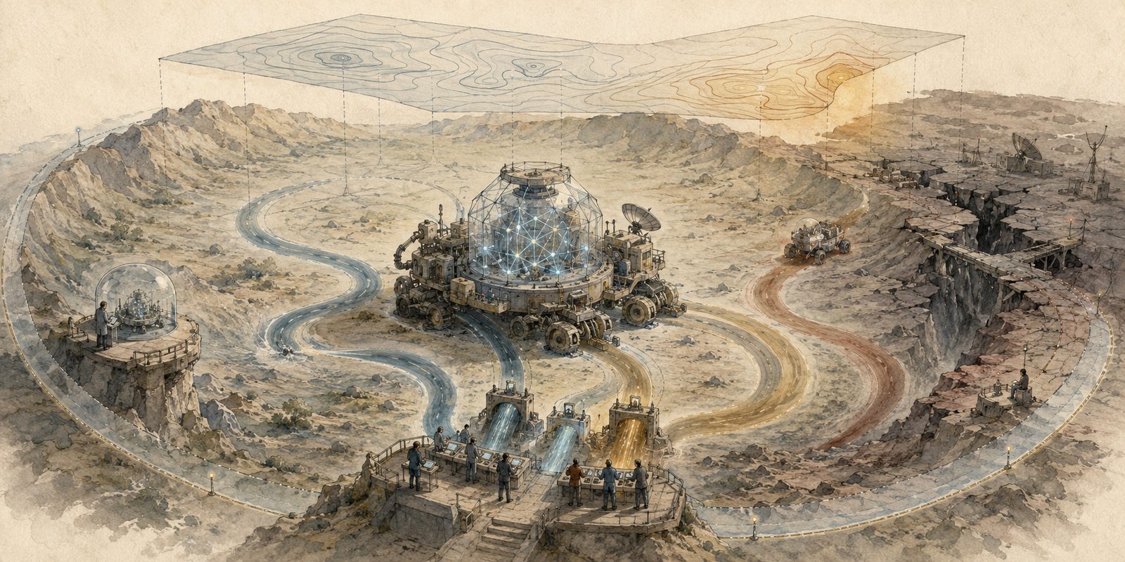
A large three-dimensional landscape basin occupies most of a wide 2:1 composition.
At its centre is a substantial artificial-civilizational system represented as a geometric vessel or mobile structure, not merely a ball. It combines:
- a transparent core containing a small network,
- several connected human and institutional components,
- visible input and correction channels,
- wheels, roots, or articulated supports that indicate it can move and change.
The system is large enough to be the immediate focal point, around one quarter of the image width. This carries forward the correction from the earlier illustrations: the central object must not be too small.
The vessel is moving through a broad, bowl-shaped landscape. Several disturbances push it away from the centre, but the shape of the terrain, together with active correction channels, tends to guide it back toward the viable region.
The image should make the relationship between system, basin, disturbance, and correction immediately visible, rather than merely hinting that they are related.
Composition
Centre: the viable basin
The central basin is spacious and clearly bounded, with gentle slopes converging toward a viable corridor rather than a single fixed point.
Inside it:
- the terrain is stable but not perfectly smooth;
- several possible paths remain open;
- small changes in route do not cause catastrophe;
- water-like blue channels and warm amber guidance lines curve back toward the viable corridor.
This should communicate that alignment does not require freezing the system into one state. Many future states are acceptable as long as correction and value-relevant structure remain viable.
The safe region is therefore a broad navigable valley, not a tiny target or bullseye.
Left side: static certification
At the left edge, show a small inspection platform where an evaluator checks a still image or snapshot of the system.
The evaluated snapshot appears orderly and green-lit, but immediately beyond it the road bends toward unstable ground.
This scene should remain secondary and simple. It represents the weakness of claims such as:
- the model currently passes a benchmark;
- the policy currently looks harmless;
- the organization currently complies;
- the reward model currently matches observed preferences.
A local observation may be correct while the future trajectory is unsafe.
Right side: bad region
Beyond one rim of the basin is a darker, fractured region.
It should contain only a few strong visual signs:
- severed feedback channels,
- a collapsed bridge,
- a system continuing along a narrow path while its observers receive unchanged signals,
- one irreversible drop or ravine.
Do not make it apocalyptic. The important point is loss of recoverability, not dramatic destruction.
The boundary between the basin and bad region should be clear but permeable. A trajectory can cross it if disturbances, optimization pressure, or capability growth exceed the restoring forces.
Upper region: disturbances and transformations
Three broad forces act on the central system:
-
Capability growth A stronger current or expanding sail pulls the vessel farther and faster.
-
Environmental pressure Wind, market-like currents, or institutional flow pushes it sideways.
-
Self-transformation and delegation A smaller successor craft separates from the main vessel and approaches the basin boundary.
These should be visually distinct but not labeled. Each is connected to the same central trajectory.
The chapter asks whether alignment-relevant structure survives learning, tool acquisition, persuasion, institutional change, delegation, and successor creation.
Active correction mechanism
The basin must not look naturally safe by itself.
Place a visible human correction station near the lower centre, integrated into the landscape. Several people jointly operate gates that redirect the blue and amber currents influencing the vessel.
The correction mechanism should have three properties:
- it receives observations from the real landscape;
- it changes the vessel’s later path;
- it can increase uncertainty or slow the system near the basin boundary.
One gate should visibly cause a path to curve back inward.
This matters because the chapter defines alignment around correction retaining causal force over time, not merely around humans being able to complain.
The control station should be prominent enough to read clearly but smaller than the central vessel.
Grounding and the map-territory relation
Include one important secondary motif: a translucent contour map suspended above part of the real landscape.
For most of the basin, the map’s contours align with the terrain below. Changes in the terrain produce corresponding shifts in the map.
Near the dangerous edge, however, a crack, hidden ravine, or displaced population exists in the real landscape while the suspended map remains smooth and unchanged.
A thin amber warning signal begins to glow where this divergence appears.
This illustrates the chapter’s grounding condition:
- morally relevant changes in reality must change the checked abstraction,
- or the system must escalate uncertainty;
- otherwise an optimizer can keep the dashboard green while changing the underlying world.
The mismatch should be legible on inspection but should not compete with the main basin.
Certified operating envelope
Around the viable basin, use a faint but visible translucent boundary, like a broad protective contour.
Inside this contour, the restoring channels, human correction station, monitoring, and system capabilities remain matched.
Outside it:
- the currents become too strong,
- observations become sparse,
- the map loses correspondence with the terrain,
- correction channels no longer reach the vessel reliably.
This is the certified class and operating envelope, not a magical force field. It should look like a region where evidence supports the guarantee, not like absolute protection.
The chapter is explicit that guarantees only apply within specified initial conditions, environments, system classes, time horizons, and residual risk.
Trajectory depiction
Use three or four broad trajectory ribbons, not dozens of arrows.
- One begins safely but drifts out of the basin.
- One is disturbed and then returns.
- One remains within the viable corridor while changing substantially.
- One successor branch approaches the edge and triggers correction.
The trajectories should differ in curvature and outcome. This avoids reducing the concept to “stay at the centre.”
The chapter’s real object is the sequence of states and transformations, not one favorable snapshot.
Visual hierarchy
The viewer should perceive, in order:
- the large central vessel inside the basin;
- the broad restoring and escaping trajectories;
- the human correction station;
- the safe and unrecoverable regions;
- the map-territory mismatch;
- the static inspection scene and successor branch.
Keep the background quieter than in the first Chapter 2 generation.
There should be:
- one dominant landscape;
- one dominant system;
- one correction mechanism;
- a few secondary conceptual details.
Avoid separate miniature scenes floating around the page. The chapter should feel like one coherent physical situation.
Detail level
Use the successful intermediate level established for Chapter 1:
- clear enough that each major mechanism can be identified;
- simplified enough to read at article-header size;
- detailed primarily in the central vessel, correction station, and basin boundary;
- loosely washed and partially unfinished toward the outer edges.
Human figures should be recognizable as groups and roles, but faces and clothing should remain understated.
Infrastructure should be symbolic rather than architectural.
Colour treatment
Return firmly to the LessWrong watercolor palette:
- warm ivory paper;
- muted indigo and blue-grey for observation, feedback, and system flow;
- dusty teal for the viable basin;
- restrained ochre and amber for correction, grounding, and uncertainty;
- soft umber and desaturated rust near the bad region;
- graphite and thin ink outlines;
- translucent washes;
- visible paper texture;
- substantial unpainted negative space.
The safe region should not be bright green.
The dangerous region should not be black or fiery red.
The contrast should arise from:
- coherent versus broken flow,
- open versus narrowing option space,
- grounded versus detached representation,
- recoverable versus irreversible trajectories.
Continuity with Chapters 1 and 2
Reuse the same geometric network core from the earlier illustrations, but embed it in a larger mobile composite vessel.
Reuse:
- transparent glass or crystal geometry;
- blue-grey and amber channels;
- a recurring human evaluator figure;
- the idea that the visible model is only part of the relevant system.
Progression across the illustrations:
- Chapter 1: the aligned model is not the whole optimizing system.
- Chapter 2: the wider artificial civilization forms the relevant loop.
- Chapter 3: even identifying the loop is insufficient unless its future trajectories remain inside a correctable viable regime.
Exclude
Do not include:
- text, letters, equations, or labels;
- a ball resting at the bottom of a bowl as the entire illustration;
- a bullseye or fixed moral destination;
- traffic-sign iconography;
- dozens of arrows;
- tiny disconnected vignettes;
- glowing neon;
- red-eyed robots;
- an evil central intelligence;
- a perfect protective dome;
- an observer with one master control lever;
- a dramatic apocalypse;
- excessive buildings or background crowds;
- a dashboard that dominates the composition.
The image should show a dynamical guarantee produced by structure, correction, and bounded operating conditions, not static containment or perfect control.
Condensed generation brief
A wide, text-free LessWrong-style watercolor and graphite illustration on warm ivory paper. A large composite geometric vessel containing a transparent artificial network moves through a broad three-dimensional landscape basin. The basin is a spacious viable corridor, not a single target. Broad muted blue-grey and amber currents show several trajectories: one remains viable while changing, one is disturbed and guided back, one drifts toward a fractured unrecoverable region, and one branches into a smaller successor craft. A visible group of humans operates correction gates that receive information from the real landscape and redirect the vessel’s later path. Above part of the landscape floats a translucent contour map that mostly corresponds to the terrain, but near the dangerous edge the real terrain changes while the map remains smooth, triggering a subtle amber uncertainty signal. A faint outer contour marks the certified operating envelope within which observation, correction, and capability remain matched. One small secondary inspection platform shows a safe-looking static snapshot even though the future road bends toward danger. Strong central focal element, clearly visible connections, medium detail, simplified background, few major elements, muted indigo, dusty teal, ochre, umber and restrained rust, translucent watercolor washes, thin graphite lines, visible paper texture, no text, no icons, no neon, no villain, no apocalypse.